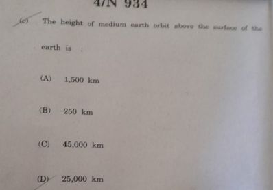
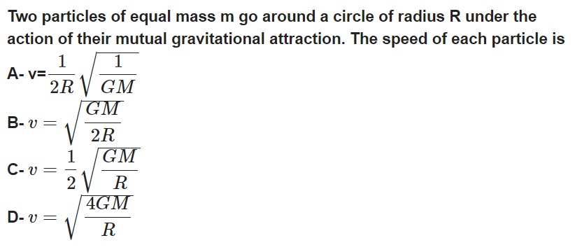
CBSE Class 11-science Answered
The earth’s gravity field, like the earth’s magnetic field, is an invisible force field. In the late 1600’s Isaac Newton demonstrated the relationship between the density (or mass) of objects and gravitational attraction between them. He theorized the gravitational pull between two objects is inversely proportional to the square of the distance between their masses. In mathematical terms: F = (G)(m1)(m2) / r2 , where F is the force of gravity, m1 and m2 are the masses of the objects, and r is the distance between the centers of the two objects, and G is the “gravitational constant”. Any two objects have some gravitational force of attraction between them. The amount of attraction decreases as the distance between the objects increases.
Density is defined as mass per unit volume. The density of a substance is directly related to the atomic weight of the element composing it, ie, elements with higher atomic weight can be thought of as being “heavier”. Another way of stating this is that equal volumes of two different substances have different densities because each different substance has a different mass (ie, atomic weight) and crystal structure. Measurements of mass can be made in a variety of different units (pounds, grams, etc...), likewise, measurements of volume can also be made in a variety of different units (cubic feet, cubic centimeters, etc...). Density is most commonly measured in grams/cubic centimeter.
Minerals (or rocks) vary greatly in density, depending on their chemical make up. Density is such a characteristic property of a substance that it may be used to identify the substance. Geologists have found it useful to develop a system of comparing densities of different minerals or rocks. This is done by measuring the “specific gravity”, which is essentially a comparison of the density of the substance to an equal volume of water. For example, the specific gravity of granite is about 2.7. This means that a cubic foot of granite, which weighs 168 pounds, is about 2.7 times heavier than a cubic foot of water, which weighs about 62.5 pounds. Typical rock-forming, silicate minerals, such as quartz and feldspar, have specific gravity values in the range of about 2.6 to 2.8 (Table below). Specific gravity values of sulfide minerals range from about 5 (pyrite) to 7.5 (galena). Native metals (gold, platinum, etc...) have very high specific gravities ranging from about 15 to 22.
|
Rock Type |
Specific Gravity |
Mineral |
Specific Gravity |
|
Coal |
1.2 – 1.5 |
Sphalerite |
3.8 – 4.2 |
|
Chalk |
1.9 – 2.1 |
Chalcopyrite |
4.1 – 4.3 |
|
Salt |
2.1 – 2.4 |
Pyrrhotite |
4.4 – 4.7 |
|
Serpentinite |
2.5 – 2.6 |
Chromite |
4.5 – 4.8 |
|
Granite |
2.5 – 2.7 |
Pyrite |
4.9 – 5.2 |
|
Quartzite |
2.6 – 2.7 |
Hematite |
5.0 – 5.2 |
|
Limestone |
2.6 – 2.7 |
Magnetite |
5.1 – 5.3 |
|
Gneiss |
2.65 – 2.75 |
Galena |
7.3 – 7.7 |
|
Basalt |
2.7 – 3.1 |
||
|
Gabbro |
2.7 – 3.3 |
||
|
Peridotite |
3.1 – 3.4 |
The standard method of measuring the force of the earth’s gravitational field is to measure the acceleration due to gravity, which was defined by Isaac Newton: g = (G)(m1) / r2 (where g is the acceleration due to gravity), and F = (m2)(g). What the formula implies is that an object which is dropped from some height accelerates (increases its velocity) as it falls. The acceleration can be calculated by measuring the velocity at two different times during the fall. Likewise, the gravitational force, or gravity field, can be calculated at any specific location on the earth using the same principle. The value of the gravity field (acceleration) is directly related to the mass (density) of the earth beneath the station where the measurement is made. The acceleration is measured with an instrument called a “gravimeter”. A gravimeter measures the acceleration by sensing the pull by the earth’s gravitational field on a mass suspended from a very sensitive spring. Gravity measurements made anywhere on the earth vary by only a few percent. Gravity surveys use the “milligal” or “mgal” (=0.0001 gal.) as the standard unit of measure (named after Galileo). The acceleration for one “gal” is equal to 1 cm per second per second.
Gravimeters are used in mineral or petroleum exploration for irregularities in the predicted model of the earth’s gravity field. The gravimeter measures very tiny increases in acceleration, which suggest the presence dense rocks or minerals (such as sulfides or other dense minerals) in the subsurface (Figure 14 – 2). The values can be plotted either along a profile or on a map (Figure 14 – 3). Anomalous gravity highs may indicate where basement rocks are closer to the surface, or where fold structures (which may form oil traps) are located in the subsurface.
Terrain Correction: If a measurement is made at the base of a hill, the mass of the portion of the hill situated topographically above the station causes an upward pull due to the attraction of the mass of the hill. Since this counteracts the pull downward by the gravitational field, a negative correction must be made. Likewise, if a measurement is made adjacent to a depression such as a large valley, a positive correction must be made.
Concept Videos
-
Potential Energy
 This video explains the gravitational potential energy and finding out the ...
 -
Gravitation
 This video explains the universal law of gravitation and the acceleration d...
 -
Gravitation
 This video explains the universal law of gravitation and the gravitational ...
 -
Gravitation
 This video explains Kepler's law of orbits.
 -
Work, Energy and Power
 This video explains the derivation of the principle of conservation of tota...